The Weather Network’s 2021-2022 Winter Forecast
OAKVILLE, ON, Nov. 29, 2021 – Record warmth, devastating floods, and even a blizzard have all grabbed headlines across Canada during the fall of 2021. While we have seen a few quick shots of early winter weather, consistent cold has been lacking so far across the country. Will this mild and stormy pattern continue through the upcoming winter? To answer this question, The Weather Network has released their winter forecast with a look ahead to what we can expect during December, January and February.
“Canadians should be prepared for winter weather whiplash over the coming months,” said Chris Scott, Chief Meteorologist at The Weather Network. “A La Niña weather pattern in the Pacific Ocean will support an active storm track across southern Canada, leading to above normal precipitation and snowfall for southern parts of B.C., Alberta, Ontario and Quebec. However, stretches of mild weather will seemingly wipe away winter at times, especially from southern Ontario to Newfoundland.”
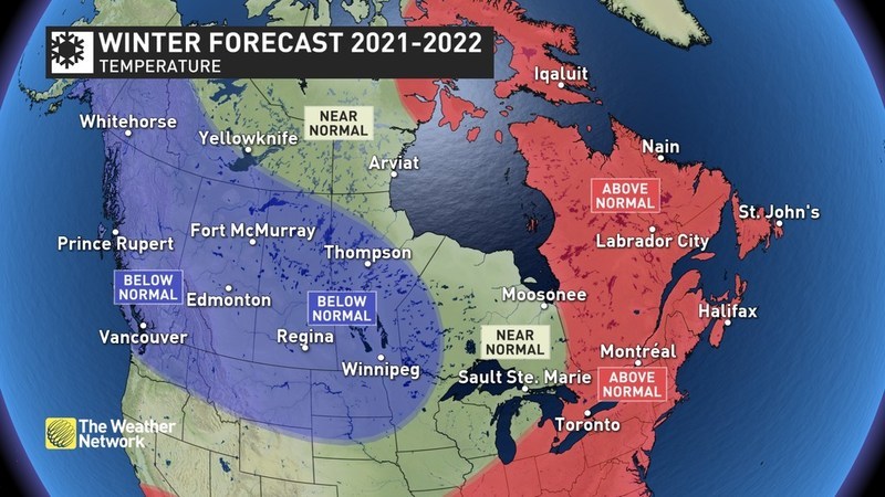
Temperatures are expected to average near to above normal across central and Eastern Canada, while temperatures across Western Canada will average below normal.
Here’s a more detailed look at what we can expect across the country during the upcoming winter season:
British Columbia
A stormy pattern is expected to continue across southern B.C. with above normal precipitation. This will bring an abundance of snow to the alpine regions, and at times significant snowfall across lower elevations as well, setting the stage for an extended ski season. Colder than normal temperatures are expected to dominate the season, especially during January and February, and linger well into March.
Prairies
A frigid winter is expected across the region, especially during January and February. While a few periods of milder weather are expected, we have a heightened risk for extended periods of severe cold. Blizzard conditions are also expected a few times as arctic air plunges south across the region. A snowy winter is expected across the southern half of Alberta and southwestern Saskatchewan. Near normal snowfall is expected elsewhere.
Ontario and Quebec
A ‘come and go’ winter is expected with periods of stormy winter weather, followed by extended periods of mild weather, including a prolonged thaw for southern areas. An active storm track will bring an abundance of snow to much of the region, but many storm systems will bring a messy mix of snow, ice and rain, especially across southern areas. While December should bring a period of traditional early winter weather, the heart of the season will lack persistent severe cold.
Atlantic Canada
A mild pattern is expected to dominate across the region this winter with above normal temperatures overall, especially during January and February. Our forecast calls for near normal precipitation, but parts of the Maritimes could see below normal snowfall totals as many systems will bring a mix of snow, ice and rain to the region.
Northern Canada
A colder than normal winter is expected across most of the Yukon and the southwestern half of the Northwest Territories. Above normal temperatures are expected for eastern Nunavut (including Iqaluit) with near normal temperatures for the eastern N.W.T. and western Nunavut. Near normal precipitation totals are expected.
Keep in mind that winter brings rapidly changing weather and dangerous travel conditions throughout Canada. Canadians should pay close attention to the daily forecast and be prepared for changeable weather by visiting www.theweathernetwork.com or by downloading The Weather Network App and creating an account for personalized and up-to-the minute forecasts.
|
The Weather Network: Winter 2020-21 Forecast |
||
|
Region |
Temperature Outlook |
Precipitation Outlook |
|
British Columbia |
Below normal. |
Above normal south; Near |
|
Alberta |
Below normal. |
Above normal south; Near |
|
Saskatchewan |
Below normal. |
Above normal southwest; Near |
|
Manitoba |
Below normal except near normal |
Near normal. |
|
Ontario |
Above normal south; Near normal |
Near normal northwest; Above |
|
Québec |
Above normal. |
Above normal, but near normal |
|
The Maritimes and |
Above normal. |
Near normal. |
|
Yukon, Northwest |
Below normal Yukon and |
Near Normal. |
Complete Winter Forecast details, including regional breakdowns, maps and charts are available at www.theweathernetwork.com/winter.
Interview opportunities: The Weather Network meteorologists are available for interviews to provide additional details and localized insights about this year’s Winter Forecast.
To arrange an interview with a meteorologist, please contact:
FleishmanHillard HighRoad
fhr.pelmorex@fhhighroad.com