El Niño’s final stand; A mild but moody spring across Canada
The Weather Network’s 2024 Spring Forecast
Oakville, Ontario, February 28, 2024 – What an extraordinarily mild winter it has been across Canada! While the past season included a monumental snowstorm for Atlantic Canada and a stretch of severe cold across western Canada, El Niño stole the show with one of the warmest winters on record and minimal snow for many. Will this pattern continue through spring?
To answer this question, The Weather Network has issued their Spring Forecast for the months of March, April and May.
“El Niño is fading, and La Niña appears to be getting ready to take the stage as we head towards summer,” said Chris Scott, Chief Meteorologist with The Weather Network. “Therefore, we expect this spring will feature profound mood swings across Canada as periods of late winter-like weather interrupt our journey towards consistent warm weather. However, we expect that warmer-than-normal temperatures will outduel the cold weather for most Canadians this spring.”
Spring is a critical season for receiving adequate rain as the growing season begins. While we expect that March will bring its share of active and stormy weather, we are concerned that large parts of the country will turn rather dry before we head into summer.
Below is a more detailed look at the conditions expected across Canada this spring:
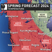
Ontario & Quebec – Spring weather started very early this year and that is a preview of what is to come as we expect warmer-than-normal temperatures will dominate the season. However, the mild spring will be moody at times with periods of colder-than-normal temperatures, a risk for significant late winter weather and even a threat for a late season frost. We are also concerned about the potential for increasingly dry conditions to develop during the second half of the season.
British Columbia – After a cooler and unsettled start to the season, pleasant spring weather is expected to dominate with warmer-than-normal temperatures and drier-than-normal conditions. Spring flooding is less of a concern this year with below normal snowpack in the alpine regions. However, this also means a shorter spring ski season and a risk for an early start to the wildfire season.
The Prairies – Warmer-than-normal temperatures are expected to dominate the season with a reduced risk for spring flooding due to a below-normal snowpack across the region. However, the temperature patterns are expected to be even more changeable than normal with periods of colder-than-normal temperatures and a few high-impact late winter events. Drought continues to be a concern for parts of the region and wildfires will be an increasing concern later in the season, especially for Alberta.
Atlantic Canada – Near-normal temperatures and precipitation totals are expected, but we also have a heightened risk for dramatic pattern changes and high-impact late winter storms. However, the periods of colder-than-normal temperatures should be offset by periods of warmer-than-normal weather. An active storm track is expected to continue through March and possibly into April before a drier pattern develops for the second half of the season.
Northern Canada – Warmer-than-normal temperatures are expected for most of the region, including the Yukon, much of the NWT and Baffin Island. Meanwhile, near-normal temperatures are expected for western parts of Nunavut. Near-normal temperatures are expected for most of the region.
Over the next few weeks, Canadians should pay close attention to the daily forecasts as weather and road conditions can change rapidly. Visit theweathernetwork.com or download The Weather Network App on iOS or Android for up-to-the minute forecasts.
| The Weather Network: Spring 2024 Forecast | ||
| Region | Temperature Outlook | Precipitation Outlook |
| British Columbia | Above normal | Below normal; Near normal southeast & far north |
| Alberta | Above normal | Near normal south; Below normal north |
| Saskatchewan | Above normal | Near normal; Above normal east central |
| Manitoba | Above normal; Near normal far north | Near normal; Above normal central |
| Ontario | Above normal; Near normal far north | Below normal south & northeast; Near normal northwest |
| Québec | Above normal south & northeast; Near normal elsewhere | Below normal south; Near normal north & far east |
| The Maritimes and Newfoundland and Labrador | Near normal; Above normal Labrador & northern Newfoundland | Near normal; Below normal northwest NB; Above normal southwest NS |
| Yukon, Northwest Territories, Nunavut | Above normal Yukon, western & central NWT, and Baffin Island; Near normal most of Nunavut & eastern NWT | Near normal |
Complete Spring Forecast details, including regional breakdowns, maps and charts are available on our seasonal page at theweathernetwork.com/spring.
For your daily forecasts visit theweathernetwork.com or download The Weather Network App available on iOS and Android and create an account for personalized and up-to-the minute forecasts.
-30-
Interview opportunities: The Weather Network meteorologists are available for interviews to provide additional details and localized insights about this year’s Spring Forecast.
To arrange an interview with a meteorologist, please contact:
Madelaine Lapointe
About Pelmorex Corp.
Pelmorex Corp., founded in 1989, is an international weather information and data management company. Pelmorex owns and operates the weather brands The Weather Network, MétéoMédia, Eltiempo.es, Clima, and Otempo.pt. It also operates Canada’s National Alert Aggregation and Dissemination System, part of Alert Ready. Through constant innovation and entrepreneurship, Pelmorex has grown to reach consumers around the globe, has become one of the largest weather information providers and has broken new ground in providing data solutions and insights to businesses. Through harnessing the value of weather, Pelmorex is driven to make the world smarter and safer for consumers and businesses.
To learn more, visit pelmorex.com and follow us on X (formerly known as Twitter) and LinkedIn.


