
Triple-dip La Niña & The Polar Vortex Deliver a Strong Start to Winter Across Canada
The Weather Network’s 2022-2023 Winter Forecast

OAKVILLE, Ont., Nov. 29, 2022 – Warm weather dominated across Canada through most of the fall season. However, the past few weeks have featured an abrupt transition to wintry conditions for most Canadians. Is this cold and snowy pattern a preview of what is to come during the upcoming winter? To answer this question, The Weather Network has released its winter forecast with a look ahead to what we can expect during December, January, and February.
“Canadians should be prepared for a strong start to winter through December,” said Chris Scott, Chief Meteorologist at The Weather Network. “A rare triple-dip La Niña weather pattern in the Pacific Ocean will team up with the polar vortex to deliver a colder than normal start to winter across most of Canada. However, winter will take a break at times with periods of mild weather during January and February, especially from southern Ontario to Newfoundland.”
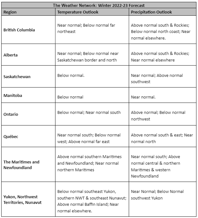
Temperatures for the winter season as a whole are expected to be near to below normal across most of Canada, while parts of Atlantic Canada will be warmer than normal. An active storm track across southern Canada through the winter season will deliver above-normal precipitation and snowfall for southern parts of B.C., Alberta, Ontario, Quebec, and into Atlantic Canada.
Here’s a more detailed look at what we can expect across the country during the upcoming winter season:
British Columbia
A come and go winter is expected with periods of mild weather and extended periods of colder than normal temperatures with a heightened risk for a couple of periods of severe cold. This will result in near-normal or slightly colder than normal temperatures for the season as a whole. Above normal precipitation is expected across most of southern B.C., including an abundance of alpine snow. This should result in an excellent ski season.
Prairies
A frigid winter is expected across most of the region, with a heightened risk for episodes of severe cold. However, a few periods of mild weather will bring a reprieve at times, especially across Alberta, where temperatures should end up near normal for the season as a whole. A snowy winter is expected across southern Alberta and southwestern Saskatchewan, with near normal snowfall elsewhere, but the entire region should be prepared for blizzard conditions at times.
Ontario and Quebec
A strong start to winter is expected with colder than normal temperatures forecast to dominate during December. Winter will take a break at times during January and February with the potential for an extended thaw across southern areas. An active storm track should bring above normal precipitation totals to the region, including an abundance of snow for ski areas. However, several systems will bring a messy mix of snow, ice, and even rain at times.
Atlantic Canada
A come and go winter is expected across the region with above normal temperatures overall for southern and eastern parts of the region and near normal temperatures elsewhere. An active storm track will bring near normal to above normal precipitation totals, but several systems will deliver a messy mix of snow, ice, and rain.
Northern Canada
A colder-than-normal winter is expected across southern parts of the N.W.T. and southern Nunavut. Above-normal temperatures are expected across eastern parts of Nunavut, including Iqaluit, with near-normal temperatures expected elsewhere. Most of the region will see near-normal precipitation totals.
Keep in mind that winter brings rapidly changing weather and dangerous travel conditions throughout Canada. Canadians should pay close attention to the daily forecast and be prepared for changeable weather by visiting www.theweathernetwork.com or by downloading The Weather Network App and creating an account for personalized and up-to-the-minute forecasts.
Complete Winter Forecast details, including regional breakdowns, maps, and charts are available at www.theweathernetwork.com/winter.
-30-
Interview opportunities: The Weather Network meteorologists are available for interviews to provide additional details and localized insights about this year’s Winter Forecast.
To arrange an interview with a meteorologist, please contact:
FleishmanHillard HighRoad
TheWeatherNetwork@fhhighroad.com
About Pelmorex Corp.
Pelmorex Corp., founded in 1989, is an international weather information and data management company. Pelmorex owns and operates the weather brands The Weather Network, MétéoMédia, Eltiempo.es, Clima, and Otempo.pt. It also operates Canada’s National Alert Aggregation and Dissemination System, part of Alert Ready. Through constant innovation and entrepreneurship, Pelmorex has grown to reach consumers around the globe, has become one of the largest weather information providers, and has broken new ground in providing data solutions and insights to businesses. Through harnessing the value of weather, Pelmorex is driven to make the world smarter and safer for consumers and businesses. To learn more, visit pelmorex.com and follow us on Twitter and LinkedIn

